Changes in black carbon emissions over Europe due to COVID-19 lockdown
Download Data
Click this link to access the data.
DOI
10.21336/gen.b5vj-sn33
Publisher
NILU -Norsk institutt for luftforskning
Creators
Nikolaos Evangeliou
Stephen M. Platt
Sabine Eckhardt
Cathrine Lund Myhre
Paolo Villani
Paolo Laj
Lucas Alados-Arboledas
John Backman
Bernard T. Brem
Markus Fiebig
Harald Flentje
Angela Marinoni
Marco Pandolfi
Jesus Yus-Diez
Natalia Prats
Jean-Philippe Putaud
Karine Sellegri
Kostas Eleftheriadis
Stergios Vratolis
Alfred Wiedensohler
Andreas Stohl
Mar Sorribas
Publication Year
2020
Resource Type
Dataset
Subject
Atmospheric Science
Contributors
Evangeliou, Nikolaos (ProjectLeader)
Dates
Created: 2020-09-18
Issued: 2020
Data Format
netCDF4
Data Policy
The data are available free of charge for non-commercial and scientific use. By using this data, you as data user accept that an offer of co-authorship will be made through personal contact with the data providers or owners whenever substantial use is made of their data. In all cases, an acknowledgement must be made to the networks and/or models when these data are used within a publication. When used, the dataset should be cited using the Digital Object Identifier (DOI).
Descriptions
Other:
The authors are grateful to all involved in managingthe sites and obstrevations during the covid-19 lockdoan periode, and back in time. Provision of observational data for this study has been acquired in the framework of ACTRIS, under the ACTRIS-2 (Aerosols, Clouds, and Trace gases Research InfraStructure) project supported by European Union (grant agreement no. 654109) and the Co-operative Programme for Monitoring and Evaluation of the Long-range Transmission of Air pollutants in Europe (EMEP) under UNECE.
Other:
Description of the different files included
AREA_EU.nc The gridded area used in the calculation including the inversion domain
CDS_web_April_E5_prec.nc ERA-5 data of precipitation
CDS_web_April_E5_temp.nc ERA-5 data of surface temperature
Country_definitions.txt Definition of the countries in the mask file Regions_0.5x0.5_EU.nc
GDP_per_capita_PPP_1990_2015_v2.nc Gross Domestic Product per capita from Kummu et al.
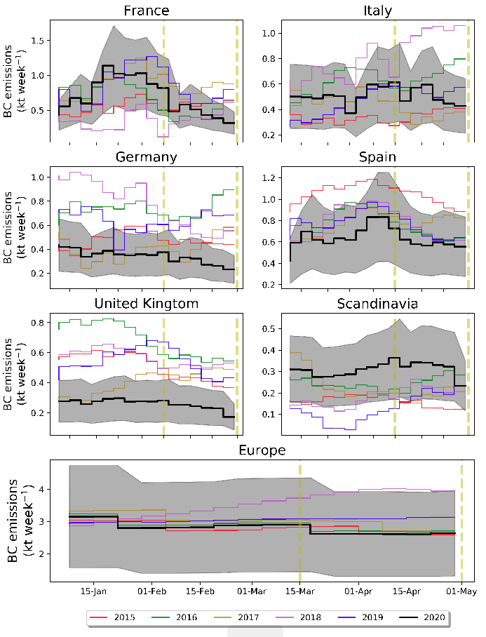
inversion_2015_ECLIPSEv6.nc Prior (ECLIPSEv6) & posterior BC emissions in 2015
inversion_2016_ECLIPSEv6.nc Prior (ECLIPSEv6) & posterior BC emissions in 2016
inversion_2017_ECLIPSEv6.nc Prior (ECLIPSEv6) & posterior BC emissions in 2017
inversion_2018_ECLIPSEv6.nc Prior (ECLIPSEv6) & posterior BC emissions in 2018
inversion_2019_ECLIPSEv6.nc Prior (ECLIPSEv6) & posterior BC emissions in 2019
inversion_2020_ACCMIP.nc Prior (ACCMIPv5) & posterior BC emissions in 2020
inversion_2020_ECLIPSEv5.nc Prior (ECLIPSEv5) & posterior BC emissions in 2020
inversion_2020_ECLIPSEv6.nc Prior (ECLIPSEv6) & posterior BC emissions in 2020. The file includes posterior emissions from inversions using constant mac values of 5, 10 and 20 m2 g-1 and variable mac values as in Supplementary Table 2 of the manuscript.
inversion_2020_EDGAR.nc Prior (EDGAR_HTAPv22) & posterior BC emissions in 2020
inversion_2020_PKU.nc Prior (PKU) & posterior BC emissions in 201
lsm_0.5x0.5-EU.nc Land-surface mask used in the calculations for the inversion domain
Regions_0.5x0.5_EU.nc Country and region masks used in the calculations for the inversion domain
regions_ghg.nc Definition of the inversion grid used in FLEXINVERT+
Surfinf.txt Average footprint emission sensitivity in the inversion domain
FLEXOUT directory It contains the Source-Receptor Matrices used in FLEXINVERT+ in monthly subdirectories. In other words, it includes the footprint emissions sensitivities from each receptor point (stations) using FLEXPART v10.4
OBS directory It contains the ACTRIS observation data (light absorption and converted to eBC concentrations)
Locations
Zeppelin:
Latitude: 78.91
Longitude: 11.89
Birkenes II:
Latitude: 58.39
Longitude: 8.25
Mt Cimone:
Latitude: 44.18
Longitude: 10.7
Ispra:
Latitude: 45.8
Longitude: 8.63
Puy de Dome:
Latitude: 45.77
Longitude: 2.96
Observatoire Perenne de l'Environnement:
Latitude: 48.56
Longitude: 5.51
Pallas:
Latitude: 67.97
Longitude: 24.12
El Arenosillo:
Latitude: 37.1
Longitude: -6.73
Montseny:
Latitude: 41.77
Longitude: 2.35
Montsec:
Latitude: 42.05
Longitude: 0.73
Granada:
Latitude: 37.16
Longitude: -3.61
Izana:
Latitude: 28.41
Longitude: -16.5
Leipzig-Eisenbahnstrasse:
Latitude: 51.35
Longitude: 12.41
Zugspitze-Schneefernerhaus:
Latitude: 47.42
Longitude: 10.98
Melpitz:
Latitude: 51.53
Longitude: 12.93
Hohenpeissenberg:
Latitude: 47.8
Longitude: 11.01
Jungfraujoch:
Latitude: 46.55
Longitude: 7.99
Funding
The Research Council of Norway (project ID: 275407, COMBAT 495 Quantification of Global Ammonia Sources constrained by a Bayesian Inversion Technique).